Updating Numerical Thermal Models to Ensure Regulatory Compliance
The Tennessee Valley Authority (TVA) manages a large system which includes fossil and nuclear plants, dams, and reservoirs.

The Tennessee Valley Authority (TVA) manages a large system which includes fossil and nuclear plants, dams, and reservoirs.
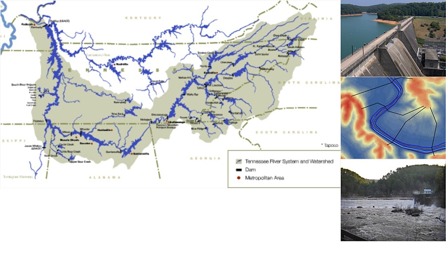
The Tennessee Valley Authority (TVA) River Operations, which regulates a system of 49 reservoirs spanning seven states, maintains Emergency Action Plans (EAPs) for dams throughout the Tennessee River System.
Geosyntec's client needed to assess redevelopment options for a 15-acre property that formerly housed a metal fabricating facility, now demolished, leaving only the concrete floor slabs.
The Tennessee Valley Authority (TVA) manages a large system which includes fossil and nuclear plants, dams and reservoirs. TVA uses a series of numerical models to evaluate water temperature and water quality in its river-reservoir reaches to help meet regulatory criteria and identify potential regulatory issues and solutions. The modeling tools used by the TVA include CE-QUAL-W2, ADYN-RQUAL, and an internally developed model (BETTER). As part of a larger evaluation of its system-wide modeling tools, Geosyntec assisted TVA in updating their numerical models used for the fossil plant river-reservoir reaches to ensure the most appropriate tools and latest versions are being used. In addition, Geosyntec improved the accuracy of some of the models, to improve their ability to predict water temperature changes. This assists TVA hydrothermal personnel with maintaining regulatory compliance while maximizing the energy system production.
Tennessee Valley Authority (TVA) River Operations regulates a system of 49 reservoirs spanning seven states and maintains Emergency Action Plans (EAPs) for dams throughout the Tennessee River system. The current floodplain maps are based on older models, assumptions, and floodplain mapping techniques from the 1980s. TVA is updating the flood mapping component of their EAPs through simulation of probable maximum floods (PMFs) and postulated failure of 10 main-stem reservoirs and 28 tributary reservoirs. Information describing the hydrology and hydraulics of the Tennessee River watershed was integrated into the current hydrodynamic model.
Metalworking and foundry operations have been the principal activities conducted on-site from at least 1917 until 2005. Groundwater investigations have shown that groundwater on-site and immediately off-site is contaminated with chlorinated volatile organic compounds (CVOCs), primarily trichloroethene (TCE), tetrachloroethene (PCE), and 1,1,1-trichloroethane (TCA). Clayey and silty regolith and fractured and karstic dolomite bedrock underlay the site. GPI Interim retained Geosyntec to 1) develop a comprehensive understanding of site conditions that influence the fate and transport of contaminants at the site; 2) establish a basis for evaluating practical management controls and assessing the appropriate final disposition of the site, and 3) prepare the site for sale to a new owner for the purpose of redevelopment.
© 2026 Geosyntec Consultants, Inc. All Rights Reserved.