Geosyntec Consultants Logo

North America

CSM Development and Remedial Design for Contaminated Soils, Sediments, and Groundwater, Greens Bayou, Houston, Texas

2026-04-02T15:50:53-06:00October 27th, 2009|Tags: , , , , |

Starting in the early 1950s and continuing over a period of several decades, arsenicals and organochlorine pesticides, including DDT and Lindane, and production raw materials and intermediates, were released into soil, groundwater, and surface water adjacent to Greens Bayou, a part of the Houston Ship Channel system. These contaminants were transported into Greens Bayou and local tributaries to the bayou via industrial discharges, surface water runoff, and groundwater discharge and upwelling. Geosyntec was retained by counsel to the Port of Houston Authority (PHA) to evaluate remediation strategies and develop remediation cost estimates to mitigate the impacts associated with this contamination loading to Greens Bayou and the tributary waterways, the most significant tributary being a large Harris County Flood Control Channel (HCFCC).

Geotechnical Engineering Design for Deep Soil Excavation Program

2026-04-02T15:50:53-06:00October 27th, 2009|Tags: , |

In its effort to expand and renew its campus facilities and related infrastructure, the Los Angeles Unified School District (LAUSD) evaluates numerous candidate sites including properties that may have been impacted by contaminants. All properties being considered for a new school are subject to a rigorous Environmental Assessment and Remedial Investigation process. At one site testing indicated that shallow soils were impacted with lead and deep soils were impacted with petroleum hydrocarbons and volatile organic compounds to such a degree that remediation was required.

Big Creek Park Wetlands Enhancement Project

2026-04-02T15:51:21-06:00October 27th, 2009|Tags: |

The Big Creek Park Wetlands Enhancement Project is a multi-disciplinary demonstration project designed by Geosyntec Consultants for the City of Roswell, Georgia, through a grant from the U.S. Environmental Protection Agency (EPA). The objectives of the project were to demonstrate innovative water quality and wetlands enhancement techniques through the use of stormwater best management practices and groundwater recharge - all within a public park setting which includes a network of trails for public use and outdoor classrooms.

Innovative Evapotranspirative Monocover and Groundwater Remediation at the OII Landfill Superfund Site

2026-04-02T15:50:26-06:00October 27th, 2009|Tags: , , , , , , |

The 190-acre Operating Industries, Inc. (OII) Superfund Site is an inactive landfill site, about 10 miles east of Los Angeles, that for 30 years until 1984 received solid waste, and for a limited period, also accepted hazardous liquids. Parts of the landfill have steep slopes and waste up to 320 feet deep. The Site was placed on the National Priorities, or Superfund, List in 1986, and the U.S. EPA has referred to OII as "one of the most contaminated sites in the country." The entire Site is in an area of high seismic exposure and is immediately adjacent to residential neighborhoods, a commercial shopping complex, and the heavily-used Pomona Freeway. More than 20,000 people live within three miles of the Site. The U.S. EPA, under multiple Consent Decrees, required the PRP Group to implement a prescriptive full RCRA cap for the landfill and a traditional pump and treat system for hydraulic control and remediation of the groundwater. The cost estimate for this remedial method was $330 million. The PRPs then began looking for a more cost-effective alternative to the capping and groundwater treatment system. Any alternative method had to not only be more cost-effective, but it also had to be fully protective of human health and the environment.

Impervious Surface Assessment Using High Resolution Satellite Imagery

2026-06-16T14:30:00-06:00October 27th, 2009|Tags: , |

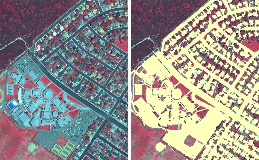
The County of Santa Barbara in southern California needed to enhance its available data resources with which to manage its stormwater runoff water quality. The County felt that there were significant gaps in existing data that it needed to make long-range planning decisions.In particular, there were significant data gaps in their GIS system, such as detailed estimates of impervious cover, recent high quality multi-spectral orthophotography, etc. These data were needed in order to facilitate the implementation of stormwater best management practices, or BMPs. Ultimately, with limited funds with which to implement BMPs, the County's goal was to prioritize which areas needed attention first in terms of retrofits, new nonpoint source water quality control, etc.

Los Angeles County-Wide Structural BMP

2026-04-02T15:49:59-06:00October 27th, 2009|Tags: , |

To date, there has been no analytically-based and comprehensive County-wide effort to optimize the selection and implementation of structural water quality Best Management Practices (BMPs). Retrofit structural BMPs were primarily selected and installed in an opportunistic, site-specific fashion, often focusing on only one specific pollutant (or source), regulatory requirement, or local funding opportunity. There had been little effort to regionally optimize structural BMP selection and implementation, particularly to meet regional goals. The County of Los Angeles, City of Los Angeles, and Heal the Bay recognized this need and combined resources and successfully secured grant funding to develop sound and defensible analytical tools to meet this gap in knowledge. Geosyntec was retained to be the Technical Consultant for this Project.

Human Health Risk Assessment and Regulatory Closure at a Site in Irving, Texas

2026-04-02T15:49:53-06:00October 27th, 2009|Tags: |

Chlorinated solvents in soil and groundwater beneath this former manufacturing facility are believed to have originated from a former waste solvent underground storage tank. Soils at the affected property consist of plastic clays overlying approximately 150 feet of competent shale. Limited contaminant migration has occurred through fractures in the clay soils. The client (property tenant) expedited site closure to eliminate financial obligation to property owner.

Decentralized Stormwater Controls for Urban Retrofit and CSO Reduction

2026-04-06T13:03:47-06:00October 27th, 2009|Tags: , |

Every year in the U.S., it is estimated that combined sewer overflows (CSOs) result in about 850 billion gallons of sewage and stormwater overflowing from wastewater collection systems. CSOs occur in systems in which municipal wastewater is conveyed in the same pipes as stormwater runoff. These systems work well until runoff from a large storm exceeds the capacity of the pipes, causing the excess water to overflow, quite often causing significant damage to homes, roads, etc., as well as potential public health issues.Eliminating these CSOs can be very costly and technically challenging. The traditional approaches include separation or construction of large, centralized end-of-pipe or interceptor solutions that can be extraordinarily expensive. The Water Environment Research Foundation (WERF) wanted to look beyond these conventional approaches and examine the effectiveness of various decentralized controls that use more natural elements to dampen the stormwater surges that can overwhelm combined sewer systems. The overall goal of the project was to provide guidance for selecting and implementing decentralized urban best management practices (BMPs) for stormwater control, and enhance these BMPs with a specific focus on reducing stormwater volume and improving stormwater quality.

Full-Scale Bioremediation of Chlorinated Solvents in Groundwater at Six Sites

2026-04-06T11:36:38-06:00October 27th, 2009|Tags: , , , |

The Aberdeen Area at Aberdeen Proving Ground (APG-AA) has operated as an ordnance proving ground since 1917, and throughout its history has been the site of testing of conventional weapons, ammunition, armored vehicles, and other equipment. During a previous Remedial Investigation, chlorinated solvents were identified in groundwater at six sites within APG-AA, collectively known as Other Aberdeen Areas (OAA). The primary contaminant of concern at all six sites is trichloroethene (TCE); however, 1,1,1-trichloroethane (1,1,1-TCA) has also been identified at some sites. The Army's objective for the OAA sites was to rapidly identify, design, build, and implement cost-effective remediation systems that will meet interim remediation goals within five years and drinking water standards within 30 years.

Preliminary TMDL and Nonpoint Source Pollution Assessment of Coastal Areas in Southern Massachusetts

2026-06-16T14:30:14-06:00October 27th, 2009|

Section 303(d) of the Clean Water Act requires states to list water bodies as "impaired" if they do not meet one or more of a defined list of water quality standards. It also requires the states to determine Total Maximum Daily Loads (TMDLs) for the pollutant(s) in each impaired water body that are contributing to the impairment. TMDLs determine the amount of a pollutant that a water body can safely handle without violating water quality standards.In 2001, the Massachusetts Department of Environmental Protection (MassDEP) classified 32 ponds and stream segments as "impaired" under Section 303(d) in the towns of Plymouth, Kingston, and Pembroke in southeastern Massachusetts. These towns fall within the state's South Coastal watershed. Many of these water bodies were impaired due to noxious aquatic plants, but other pollutants included metals, turbidity, bacteria, and nutrients.The regional watershed coordinator with the MassDEP for the South Coastal watershed identified the need to conduct a further investigation of the 32 listed water bodies to assess the nature of the pollution problems and to identify which water bodies were in most need of attention.

Go to Top